
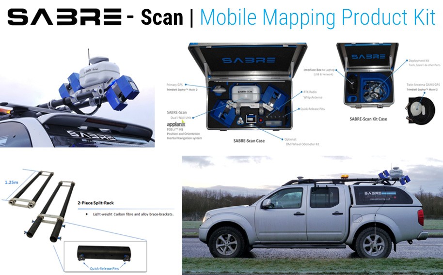
SABRE-SCAN MMS
SABRE-SCAN Mobile Mapping LiDAR Survey used during (or as part of the) development of road infrastructure.
The mobile mapping with the SABRE-Scan for Road Mapping can be carried out from the safety of a vehicle at up to highway speeds. Applications: urban planning city mapping and more, please enquire for a comprehensive list.
Data capture of up to 1 million points per second to generate high resolution 3D Point Clouds. The laser scanner utilised with the SABRE-Scan is offset at 30 degrees from vertical for improved capture of vertical objects.
- Rapidly Survey Large Areas / opening up new opportunities
- Effective and Efficient 3D Data Collection
- Providing you with Accurate 3D information you can measure
- Risk Reduction: Increased safety by survey from the security of a vehicle
- High-Resolution: Detailed 3D Point Cloud data allowing confident information extraction
- Ground / Marine / Airborne: Easy and Flexible Deployment
- Expandable Modular Solution: shared positioning/orientation with other sensors (e.g. GPR, underwater survey equipment, machine-vision imagery).

The image above shows the different routes driven by the survey vehicle carrying the SABRE-SCAN LiDAR Mobile Mapping system used to generate the multi-pass raw point cloud data as displayed. All data shown is in its raw form.

The zoomed in screen-shot above shows multiple passes of the system scanned along either side of the road travelling in opposite directions.
Mobile LiDAR Mapping - Complementary to Main-Stream Surveying Techniques
The SABRE-Scan mobile mapping product utilising LiDAR and Imagery combined with inertial-navigation is intended to complement standard mainstream/conventional survey techniques. Both static and mobile scanning can and should be used together as both have advantages for given circumstances/requirements respectively. The use of this approach can be used to radically reduce acquisition time and end-to-end delivery of accurate 3D information.
Mobile mapping has the ability to capture its surrounding environment at high-speed with high-definition point clouds spatially positioned with high accuracy and precision.
The SABRE-Scan system can accommodate a range of IMU?s dependent upon application from mid to high range The SABRE-Scan product provides superior performance dependent on the particular grade of IMU employed.
SABRE mobile mapping systems are compact, light-weight and can be attached to a diverse range of vehicle/mobile platforms - pickup trucks, cars, quads, tractors, vessels/boats and small helicopters. The choice is yours!
Georeferenced Imagery Solutions Available. Ladybug5 Panoramic (360) Video Camera Plug and Play with the SABRE-SCAN mobile mapping product. The Ladybug5 uses machine vision camera global shutter type camera lens which mitigates motion blur for image capture from a moving vehicle/platform.
Please ask for other available solutions:

